SEME – ADVANCED MOBILITY SERVICES
The SEME project aims to overcome the problems of urban mobility by seeking an optimal “dynamic” rather than “static” solution to the problem.


The system will make it possible to collect a whole series of information to implement policies to encourage citizens’ behavior. This information may come from mobility operators, field personnel (vigilant), third-party services already up and running, and finally from the sensor network.
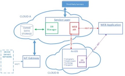
The developed modules can basically be divided into 3 units:
IoT Gateway
Service Layer
Web Application
User Functionality
The SEME system provides for the development of a multi-platform portal for interfacing single or multiple users with the public administration and the control room.
In particular, it is planned to create a web interface, with different views depending on the user.
This interface provides the user with the ability to access their profile. Once logged in, the user will be able to view their credit, if necessary to increase it by using a credit card, they will also have access to the services (reservations for rest areas, route planning, etc.), they can also perform payments for the various services requested, and it will be possible to view the history of actions and the services that used.
Furthermore, a decision support software will be developed for the Public Administration for management of the operational scenario and the software for the management of crisis situations and planned or to be planned interventions.
Other utility functions included in the planned tasks concern the management of payments and the “quality of service”.
The software will include both the management of information to the traffic police and the various traffic operators to report interventions for sanctions or emergency situations and the management of optimal routes through multimodal navigators.
All these features will be implemented within the Portal, which corresponds to the Web application. The Web application will be composed of a server-side part (which manages the application logic) and a client-side part (display), moreover the client will use the functionalities of the GIS component for the management and visualization of the territory. The general scheme of the application is shown below.
Web Server: the application structure provides for the implementation of dynamic Web pages, where the data is processed on the server side and sent via dynamically constructed web pages to the client for viewing. The client-side web application will be developed with Java (or .NET) technology using the MVC framework. The application will interact with the SEME system by accessing the WebAPI provided by the service layer.
Web Browser: the browser will be the tool through which the user will access the SEME system services. The web pages of the application will be displayed through the browser. Web pages will be built with HTML5 and JavaScript technology, possibly using client-side frameworks such as jQuery (ExtJS / AngularJS). The GIS component for displaying the territory will be included in the application web pages.
GIS: the GIS component is not part of the portal to be developed as it is a tool already available. ESRI technologies, in particular ArcGIS, will be used for this purpose.
Functionality
– Payment
– Reservation
– Multimodal navigation
– Remote tele-control
Services
Parking control services will be divided into two categories: special parking and generic parking.
Special car parks include car parks for the disabled, car parks for loading / unloading goods, car parks for recharging electric vehicles, car-sharing car parks and car parks for tourist buses.
The normal paid parking lots are included in the generic car parks.
In this first phase, we will study and develop a system applied to the management of tourist buses that uses innovative GPS-based precision localization services, developed from technologies implemented by the Esri Italia specialized geomatics unit.
Multimodal navigation and advanced cartography services will develop from Esri technologies. In particular, navigation services will be developed including discovery, booking and guidance to the nearest reserved parking.
As we understand the same services (discovery, booking and navigation), they can be applied to special car parks for goods, electric cars or car sharing as well as for tourist buses.
With regard to management, the system will provide information to control stations or parking control staff about the illegal occupation of a reserved parking space or a parking space reserved by others.
It is also clear that the system will study and experiment with advanced payment systems, both for services to private citizens, and for the services for the use of reserved goods loading / unloading areas.
Other services provide for differentiated payment for access to the ZTL depending on the area, the weather, and also the type of vehicle.
Furthermore, a navigation service will allow, based on “policies” chosen by the PA. To cross a ZTL at minimum cost (for the user) and with minimum impact (for the territory).
Finally, the system will make available to the PA a series of services to manage incentives and access costs according to dynamic parameters, therefore a whole series of tools for decision support having available a whole series of data accumulated over time.
Below is a list of services made available to system users.
- Map view
- Parking reservation
- Route calculation
- Navigation
- Account management
- Credit management
- Infringement management
- Sensor information
- Historical data analysis
- “Policy” management
- Zone / event definition
- Accounting management
